
In my previous post based on the photo travelogue of Mary Loosemore, I covered the journey of the 11-member Hindu Kush adventure group, that also included Mary Loosemore, from Peshawar, Pakistan to Dir and Ayun through the Lowari Pass. Today I will cover the group's adventure, as photographed by Mary, into the fascinating world of the Kalash Fairyland - the Kalash Valley.

Kalash Valley consists of three sub valleys as shown in the map below. The Mary Loosemore's group selected the Rumbur Valley to explore the hidden world of the Kalash people. On 4 October 2006, they reached Balanguru for a night stay with the Kalasha.
From south of Chitral, a track turns to the left from village of Ayun on Kunar river to the Kalash Valley, where these strange yet attractive people live in three main villages and surrounding areas of Rukmu, Mumret and Biriu (called Rambur, Bumburet and Birir in local Kalasha language).

A Kalash woman dressed in traditional black robe ornamented with multicoloured beads and headdress
Kalash Valley consists of three sub valleys as shown in the map below. The Mary Loosemore's group selected the Rumbur Valley to explore the hidden world of the Kalash people. On 4 October 2006, they reached Balanguru for a night stay with the Kalasha.
From south of Chitral, a track turns to the left from village of Ayun on Kunar river to the Kalash Valley, where these strange yet attractive people live in three main villages and surrounding areas of Rukmu, Mumret and Biriu (called Rambur, Bumburet and Birir in local Kalasha language).

Map showing the route to three Kalash Valleys from Ayun
Bumburet is the largest and the most picturesque valley of the Kafirs, is 40 kilometres from Chitral and is connected by a jeepable road. Birir and Rambur are located at a distance of 34 and 32 kilometres respectively from Chitral. The present population of the Kafir Kalash is approximately 6,000.

Road to Rumbur Valley - Photo: verdanega / Panoramio
The villages are situated on the southern face of the hillside about 50-100 meters above the river. This protects them from floods in summer, and at the same time helps to get sunshine during the winter. The snow that lies on the bottom of the ravine and in the shade do not melt until spring.
In summer to avoid the sun, some people live in a second house built on the opposite side of the river. The Kalash Valleys have extensive forests of Holly-Oak and Himalayan cedar. Walnut, Apricot, Apple, Pear and Mulberry trees abound near the villages.

An almost three days stay in the Rumbur Valley, moving from one village to another, provided Mar's group a deep insight to the life, culture, traditions and lifestyle of the Kalash people. Following are the photos taken in the Balanguru village of the Rumbur valley.




Utchal: This colorful event is celebrated in mid-July to mark the harvest of wheat and barley. The two- day celebrations feature dances, singing and hosting feasts.


 Mary Loosemore at the top of the tree line, passing over the coll between Shakanande valley and the Rumbur valley


 |
| A typical Kalasha village on the mountain terraces in the Rumbur Valley |
In summer to avoid the sun, some people live in a second house built on the opposite side of the river. The Kalash Valleys have extensive forests of Holly-Oak and Himalayan cedar. Walnut, Apricot, Apple, Pear and Mulberry trees abound near the villages.

Pakistan flag flutters near a house in the Balanguru village - Rumbur Kalash Valley
An almost three days stay in the Rumbur Valley, moving from one village to another, provided Mar's group a deep insight to the life, culture, traditions and lifestyle of the Kalash people. Following are the photos taken in the Balanguru village of the Rumbur valley.
 |
| A Kakasha child with shinning green eyes - typical of Kalash |


A Kalash women laughs as 'strange men' crack jokes

Benedict, one of the group member, shows photographs taken of the Kalash children on his camera

Lunch at Saifiullah Jan's new house, the local host at Balanguru village

Kalash children en route to their school

A walk through Balanguru village

Kalash girls en route to their school 

Mary had her hair plaited the Kalasha style by small Kalash girl

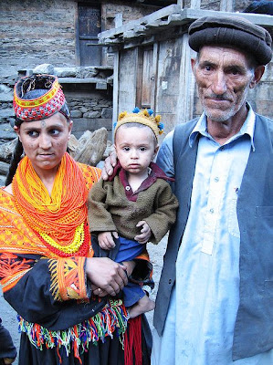
A Kalasha family

Kalash girl hand weaving for tying the hair

Style girl at Balanguru

Kalasha girls group photo
Those who visit the Kalash Valley in early summers, they can attend Kalash festivals held in the early summers. The two main important festivals are Joshi and Utchal. In the late summers and winters, two more festivals Phool (20th-25th September) and Chowas (18th to 21st December) can be attended, though the latter is very difficult to attend owing to losure of the Lowari Pass. However, if one can make it to Chitral by air, then from Chitral to Kalash Valley by local jeeps is possible.
Joshi or Chilimjusht: This festival is held from 14th to 15th May to mark spring when girls pick the first flowers of the season. Traditional dancing, visiting each other, exchanging flowers, milk and milk products are its features.
Utchal: This colorful event is celebrated in mid-July to mark the harvest of wheat and barley. The two- day celebrations feature dances, singing and hosting feasts.


Pre-dinner cricket match: Hindu Kush XI vs Kalash XI!! [above/below]


Dinner being prepared at Balanguru village rest house

A hearty dinner and smiles

Balanguru village as seen from Safiullah Jan's guest house
After Balanguru, the group visited the village of Shakanande. The following photographs were taken during their visit to Shakanande:


Shakanande Village, Rumbur Valley

Mary crossing a stream in the Shakanande village

A boy entering the house through a carved door - specialty of the area
The last village the group visited was that of Palaga. Here in under are some of the photos taken at Palaga Kalash village:

Daughter of the host

Annie and Amanda during a hike near Palaga village - eating locally grown grapes

Dinner being prepared at Palaga

Mary, Annie and Amanda - Dinner is over

The group en mass at camp fire night [ Saifullah, Mary, Annie, Amanda, Rob, Annie, Benedict, Thelma ]

Hikers resting for a quick snap

View from the Palaga rest house

Relaxing at charpoys - native beds with four legs at Palaga

Kalash family


Grandmother with her niece
After a three days long stay in the Kalash Valley, the Hindu Kush adventure group moved to Chitral for a day's stop, before resuming their journey onward in the Hindu Kush range to Gilgit, through the Shandur Pass. My next posts will cover the stop over to Chitral and travel to Gilgit.
Read more about Kalash and their festivals:
Kalash Valley - Where Fairies dance and sing (Pakistanpaedia)
Kalash Spring Festivals (Pakistanpaedia)
All photos above, except where specifically mentioned, are owned by Mary Loosemore, as shared on Flickr.


-1.jpg)
.jpg)


