Showing posts with label Balochistan. Show all posts

Monday, July 8, 2019

Balochistan the Unexplored Travel Destination: Living with a Nomad Balochi Family

The onset of summers makes a large number of tourists moving from plains of Pakistan to the northern areas to escape the scorching heat. This year, there has been an unexpected  influx of tourists  not to Murree, the otherwise favoured hill station, but far up north to Gilgit and beyond, Naran and Babusar Top, and then descending to Hunza and onward to Khunjrab Pakistan-China border.

more and more tourists from abroad are touring Pakistan, taking back fond memories of love, warm hospitality and meeting with diverse people of Pakistan. I  have already shared experiences of Kimberley Clark and Drew Binsky

Now here is yet another daring lone lady venturing the unexplored travel destinations in Balochistan province of Pakistan, the barren, arid, almost vast lifeless stretches of muddy plains and muddy mountains and still enjoying her sojourn with people in their original nomad living. 
I am talking of Rosie Gabrielle, the lone motorcyclist, who dared the unexplored vastness of Balochistan and experienced staying with a Balochi family not living in some city but out in nowhere in a makeshift tent with no amenities of life whatsoever. Her travel across Pakistan is something different. Her account shows a life different in Pakistan than what media tells the world. She is simply inspired by their plain hospitality and love for others and her love for them - the ordinary people.


Despite the poverty, the family welcomed Rosie Gabrielle who stayed with them, lived the life they lived without any comforts of life. Yet the family was hospitable and staying with them was a experience of lifetime for Rosie. The woman of the house truly touched her heart, says Rosie. She ate with them, had her hair done up, dressed like them and played with their children. Recently she did a fundraiser to provide them with solar panels so they can have fans for the hot summer heat.  

Saying more would deprive you of the charm her video carries, so just watch her video as shared on YouTube and see her lifetime experience of living with a Balochi family and experience what she did not expect:
I will share her videos of travel in Pakistan, but seeing the video don't you think how safe is Pakistan where a lone female biker can roam in the wilderness all by herself and does not even feel threatened living with people she didn't know at all!!

Photo: Screen shots | References | 1
If you like Jaho Jalal, please follow us on Facebook

Friday, February 8, 2019

Pakistan: Your Travel Destination 2019 - Part VII - Pir Ghaib (Bolan), Balochistan


Balochistan province, that is the largest province of Pakistan as far land mass is concerned, is mostly an arid desert and mountainous. There are large tracts of treeless in most of the province due to lack of rainfall. But wherever there is water available we see lush green orchards, apple gardens and water falls. 

Pir Ghaib is one such place which located amid barren rocky mountains is a cool refreshing place with a waterfall and blue green water pond, surrounded by tall palm trees and lush green bushes. This serves an attractive tourist resort, specially in summers, when the area around is baked by strong sun rays. Pir Ghaib waterfalls is in fact a beautiful cascade located some 70 kilometers away from the province's capital Quetta.

Pir Ghaib literary means a pious man who disappeared or an invisible saint. No one is really sure why the place is so called but folklore legends relate that a saint and his sister had come to the area to convince the locals who worshiped fire to convert to the true faith of Islam. When the local king came to know of the presence of these two "dis-tractors" he dispatched a contingent to catch or kill the duo. When being persuaded in a gorge, the two decided to split lest being caught together.

[Photo: Facebook/Hunza]
While the sister followed the gorge, the saint fled into this arid landscape with the army in hot pursuit. And found his way up the Bolan mountain but reached a dead end. It is said that he started clawing at the mountain and when soldier almost reached him, the saint vanished inside the rock. And from that point a stream sprang in a form of waterfall that cascaded down into the area and filled it up and formed a pond. Due to presence of water, vegetation started to grow and soon became an oasis. Since that day, this oasis is called Pir Ghaib - the Invisible Saint.

And the amazing part of the folklore is that till date no one has been able to locate the source of water that oozed out of the rocks !!


There is a grave downstream the gorge there is a grave which is said to be the that of invisible Saint’s sister, known as Bibi Nani, located under a bridge by the rocky bank of a seasonal stream.
There are no details available as to how and when did Bibi Nani die or how was she buried at this place. Although not a saint herself, her grave is revered as such. In mid October, 1986, a huge flood struck the area and destroyed much of the habitats, roads and bridges not even spared. But astonishingly the grave of Bibi Nani was spared. Due to this fact, the grave of the Bibi assumes much reverence by the people of the area.

Many tourists from adjoining areas and as far away as Quetta visit this place, specially in summers to enjoy the cold water of the oasis, take a dip or just walk around or sit under the shade of the palm trees. Unfortunately there are no facilities available except for a small shop selling eatables and chips. Tourists normally carry their meals or cook here in the absence of an eatery.

You may like to watch this informative video below which describes the history and tourist facilities available around the place and how to get to this oasis from Quetta:
If you happen to be in Quetta, do take a time out and visit Pir Ghaib - it is something that you will really love it. 
Photo: Pir Ghaib (Screenshot) - Photo Grave Bibi Nani | References |  1 |  2 | 3 | 4 | 
If you like Jaho Jalal, please follow us on Facebook

Tuesday, February 5, 2019

Pakistan - Your Travel Destination in 2019: Part V - The Train Wading through Sea of Snow (Balochistan)


There are many videos on the social media networks showing trains passing through heaps of snow, shoveling away showers of snow to the sideways as the travel through tons of snow stacked on the railway tracks. It is really fascinating to watch such videos.

The Quetta section of the railway in Balochistan province of Pakistan passes through very high elevations including one Kan Mehtarzai once again. The place between Kuchlag and Muslimbagh became the highest railway station of Asia, located at a height of 2,224 metres (7,295 feet). I wrote about Kan Mehtarzai in one of my earlier posts. and it too gets covered in snow during winters.

Many years ago, I had a chance to travel by train to Quetta in winters and saw snow covered surroundings as the train moved on. In those days there were no cell phones, what to talk of camera phones so that I could take videos or even still photos of the area. I regretted to even not having my camera with me.


But recently I came across a video on Facebook which brought back the nostalgia of my earlier visit to Quetta by train. And this video by someone lucky enough to have preserved a beautiful scene of train wading through a sea of snow at Kolpur railway station near Quetta. It is really amazing scene and I must appreciate the train drivers who drive their trains through the severely cold regions in trains that are not even air conditioned engines.Even most of the train is not air conditioned and one can imagine the plight of passengers inside. However, despite all odds, the travel goes on and people keep moving and train drivers continue to brave through the seas of snow everyday, every winter, each year.

Watch the beautiful video below showing the train braving through enormous sea of snow:
If you happen to be visiting Pakistan in winters, do take a ride to Quetta by train - you will simply love it.

Also read my posts: Breakfast at Kan Mehtarzai
If you like Jaho Jalal, please follow us on Facebook

Tuesday, May 7, 2013

The Karez System: the Nature's Way of Solving Water Scarcity in the Balochistan Province of Pakistan

Many of us know Balochistan province of Pakistan to be a water-less area - with water not seen for miles apart. We humans have not been able to do anything about the scarcity of water in vast tracts of barren lands of the province. But Nature has developed such a system of underground water channels that astounds even the best of technologies: the Karez System.


I recently came across a very informative blog post written on the subject by my friend Syed Asghar Javed Shirazi and thought of sharing it with my readers. Herein under it is:

West of Indus Plains and out of monsoon zone is Balochistan – the largest landmass in Pakistan with an area of 343, 000 square kilometres.

Balochistan is scarcely populated, mainly due to its daunting arid geography. It includes the mountainous country separated by intervening valleys. Balochistan receives very low rainfall annually. But innumerable natural springs known as "Karez" and streams are found in most of the areas.

The ancient Karez system is comprised of a series of wells and linking underground channels that uses gravity to bring ground water to the surface, usually far from the source. Originally ancient towns used to depend on the streams and rivers nearby into which glaciers in far-off mountains used to feed. As the time passed the glaciers gradually shrank over the centuries, the streams they fed likewise diminished, resulting in less water flowing downwards. Then people ingeniously created the Karez to draw the underground water to irrigate the farmland. Wells begin at the base of the mountains along the contours of the hillside. To keep the underground channels unclogged, two men and a draught animal work as a team - one man is lowed down to clear the tunnel and buckets of mud are hoisted to the surface by the animal. The tunnels slope less than the contours of the geographical depression, so that the water reaches close to ground level. The water in Karez will not evaporate in large.


This technology that originated in the Chinese deserts west of the Himalayas is also commonly used in the highlands of Balochistan, although with some minor modifications. Though it is not known how it reached here. Small water channel that are built along the hill gradient for maintaining the proper gravity flow of water are found in Balochistan in many places.


A view of Karez in Sooro, Mand, Turbat. Aug 25, 2005
A view of Karez in Sooro, Mand, Turbat Balochistan (Photo: Danyal Gilani - FLickr)

The Karez irrigation systems rely on gravitational pull and are comprised of simply a water source, underground tunnels, and vertical shafts that feed the water scarce areas. These irrigation systems are owned and operated wholly by the community. Some work is being planned on to re establish the Karez irrigation system at the sub-tehsil level.

The ancient and social water supply system can be reactivated for obvious reason: To improve the socio-economic status of the people of Balochistan, by helping them realize the importance of the Karez system and facilitate self-help activities for rehabilitation of the same; to identify and understand ground water irrigation system deficiencies and the causes for its abandonment by the community; to re-instil a sense of confidence in the Karez system among local communities; to protect, excavate and extend the Karez system in the other areas; to incorporate a delay action mechanism in the Karez system and to check the dam for efficient groundwater recharge; to train community leaders in the efficient operation and management of Karez.

Cleaning of Karez is considered collective social responsibility and people work for it on self-help basis (like bhall Safai in Punjab). Once there existed a large network of these Karez's in the province. The system has very low operational cast, it not only fulfills daily need of usage of water but also irrigates orchards and supply water for cultivation. We should try to keep the system alive. These are social streams as well.

( via Light Within
If you like Jaho Jalal, please follow us on Facebook

Sunday, March 25, 2012

Sleeping Beauty and Quetta

I first heard of Quetta from my mother in my early childhood when she once narrated her eye witness account of an earthquake that rocked Quetta in 1935. She, as a nine year old, was there as her father was posted in the railway police at that time. She narrated as how in seconds, the entire city was gone leaving countless dead, miraculously saving her and her family.

Devastated Quetta after 1935 Earthquake
But it was not till some twenty two years later that I myself boarded a train and arrived at Quetta. It was a thriving business centre of Afghan and Iranian goods, as it even continues till date. I along with many of batch mates was housed near the “Pani Taqseem (meaning water distribution square)” chowk for the duration of our training at the School of Infantry and Tactics. While the day took a heavy toll of us in the treacherous training grounds, the evening were spent roaming in the markets on Jinnah Road, fully loaded with foreign stuff, electronics, eatables and cloth, mainly brought in from Afghanistan and Iran. 

Then there were shops selling sizzling hot chickens, meat and beef cooled in traditional Balochi style. The most famous being the “Sajji” – chicken with their bodies stuffed with rice and boiled eggs and baked around burning fire by splashing oil and adding more life to the flames.

I again revisited Quetta some eleven years later – this time I came by road from Sukkur, Jacobabad (my accounts of Jacobabad can be found in an earlier post) and Sibi and still enjoyed the warmth of hospitality of people of Quetta. Quetta and surrounding areas are famous for sweet apples, grapes and God knows how many kinds of fruits. The famous Hanna Lake outside Quetta, which feeds the city for its requirement of water, is a refreshing place to visit. 

Watch closely above: The Sleeping Beauty Lies in peace [Photo: Jalal HB ]
Ever seen Sleeping Beauty - once a friend asked me? And when I showed my ignorance about it, he actually took me for a ride on his car and we went a little outside of Quetta and then he showed my the majestic Sleeping Beauty. 


The head of the Sleeping Beauty
She was there lying on her back with all her grace and majesty. If you follow the above mountain feature from the right, that is the head, then moving left, the torso and then the legs - one has to imagine a beautiful beauty lying. I did and I saw her.


Quetta Photos
The above close up of clearly shows the head and bosom of the Sleeping Beauty [This photo of Quetta is courtesy of TripAdvisor]

Those interested in wildlife can head to Hazarganji Chiltan National Park, which is about 20 kilometres from Quetta. The park is home to  five distinct kinds of Markhor (wild sheep), leopards, wolves, striped hyena, hares, wild cats and porcupines. The park also has a large number of birds that include  partridge, warblers, falcons, blue rock pigeon, rock nuthatch, red gilled choughs, golden eagle, sparrow, hawks, falcons and bearded vultures.


Although, I did not visit the Archaeological Museum at Fifa Road then, I have come to know that the remains of recently discovered  Baluchitherium (Indricotherium Transouralicum), a gigantic hornless plant eating rhinoceros like animal are also preserved here.

Quetta continues to live a life of its own – a city with very different mood and environment. The ruggedness of the Balochistan province eases out here in the shape of warmth of hospitality and love. I would someday love to go there again – this time equipped with my digital gadgetry to shoot the beauty of Quetta and the gardens around it.

If you like Jaho Jalal, please follow us on Facebook

Thursday, March 31, 2011

Princess of Hope


She stood there, namelessly, for God knows since when – right there in the wilderness along the coast of the Arabian Sea, wearing a royal robe and a hood. The wind whistled around her, teased her but she could not stop the winds as the fast blowing winds swept past her and blew dust around her. No one visited her and she felt extremely lonely. Her only companion in he area was a huge Sphinx of Giza, Egypt like feature who shared her loneliness.

Then one day she saw huge creatures, yellow in colour with black round objects making them move and cutting a way through the mountains. Then a black limning was put on the areas that were cut and leveled by the strange creatures that she hadn’t seen before. And then she saw people started to move in smaller creatures with speed on the black carpet spread near her. She saw one of the people stopping and looking at her with awe and wonder in his eyes. She was happy that she was finally found. More and more people started to visit her, staring at her and taking her photographs.

Princess of Hope

One day a tall woman flanked by others came all the way from Hollywood, started at her and then called her Princess of Hope. Suddenly from obscurity, she became famous and made headlines across the world. A blue board was erected on the road pointing towards her direction with her new name on it. The lady that gave her name was none other than Angelina Jolie, the famous Hollywood actress and the UN ambassador of goodwill.


The exact location of Princess of Hope is about 275 kilometers from Karachi. So if you live in Karachi or visiting Karachi, take a day off for a drive by taking the N25 national highway to Hub from Karachi. Passing near the post of Gadani, famous for its ship breaking industry, Wander and Sonmiani beach, the Makran Coastal Highway starts about 10 kilometers short of a place called Uthal with a clear blue sign indicating the direction. While N25 continues due north, the Makran Coastal Highway branches off towards west (left). Much before the village of Sangal, you will find dirt track leading to Chandargup towards your left. Chandargup is the highest mud volcano in the area.


In about three hours’ time one will reach the Hingol River and the Hingol national Park. From here you can also visit a Hindu temple called Nani Mandir, which is off the main highway by some 6 kilometres. But for doing so, you must have a good and robust jeep as ordinary cars may not reach the place. Nani Mandir is an important Hindu pilgrimage. The visit or the pilgrimage is also called ‘Nani ka Haj’.


Continuing your journey on the Marakn Coastal Highway after crossing the Hingol River, you will reach the Kund Malir Beach. From here the coastal highway moves directly up north entering you into the Buzi Pass. Flanked by the mud mountains, the road starts to turn towards west (left). From here one would first come across the Sphinx and then he Princess of Hope.

Going further west, the road would start to descend towards Rudeni Band and would finally lead to the Ormara seaport. The same road continues west towards Gwader, but that’s a long drive ahead. For a day’s journey, one should not go beyond Ormara, unless arrangements for night stay at Ormara are tied up.

Related Reading:
Hingol National Park (Pakistanpaedia)
If you like Jaho Jalal, please follow us on Facebook

Wednesday, March 30, 2011

Mud Volcanoes of Pakistan

Chandergup Mud Volcano

A couple of days back I wrote a post on the Pakistani Sphinx, a Sphinx of Giza, Egypt like feature, but naturally carved and shaped by high speed winds along the Makran Coastal Highway in Balochistan province of Pakistan. A friend of mine who had been wandering in the area for making roads and other infrastructure immediately called and wondered if I knew more about the area. Well I had my answer in negative as I had not been to the area.

A photo slide of mud volcanoes

Scroll down for a video of Chandergup  mud volcano

He then told me about the mud volcanoes of Balochistan, which are considered to be one the largest and highest of their kind in the world. I was amazed and awestruck and asked him to send me details about the volcanoes. He said he would and asked me to find a place called Aghor along the Makran Coastal Highway and then look towards its north east. And when I did on Google Earth, I easily spotted a line of volcanoes clearly visible as shown below.


Mud volcanoes, often referred to as mud domes are formations caused by geo-extracted liquids and gases. When the hot water mixes with the surface deposits, these form mound like shapes, with a conspicuous contrast from the surroundings. These volcanoes emit gases, a major portion of which is methane, besides nitrogen and carbon dioxide. Azerbaijan is famous for its highest volume of mud volcanoes in the world.

As per Wikipedia, there are more than 80 active mud volcanoes located in the Balochistan province. These volcanoes are located in clusters spread over almost ten locations, mostly between the Gwader Port and Delta of Hingol River. Near Gwader, these mud volcanoes are very small and mostly sit in the south of Jabal-e-Mehdi toward Sur Bandar. Many more exist in the north-east of Ormara. And as mentioned by my friend, I saw a major complex of volcanoes located in Lasbela District, scattered north of Miani Hor in the Hingol Valley and almost north of the Agor beach. In this region, the heights of mud volcanoes range between 800 to 1,550 feet (243.8 to 472.4 m). 


-->

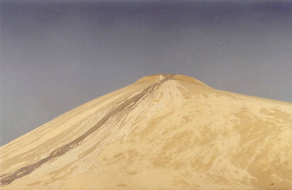
The most famous is Chandargup, which is located some three and a half miles south of the Makran Coastal Highway and 15 miles short of village of Sangal. The sea shore from Chandargup is around three and a half miles down south. 


However, the biggest crater is located north of a place called Sangal, east of the complex of volcanoes north of Agor (25°33'13.63"N. 65°44'09.66"E, located almost in between Karachi and Ormara port), which is about 450 feet (137.16 m) in diameter.

The biggest crater - about 450 feet (137.16 m) in diameter

The liquid mud that oozes out of these volcanoes is said to have healing powers and many people throng the area, despite the difficulties involved in reaching to these volcanoes to cure skin diseases. The phenomenon is identical to people going to hot water springs and taking bath for curing skin diseases. I remember such springs in Ramsar, Iran where the entire area has the aroma of sulpher which abounds in the hot water springs. However opening of the Makran Coastal Highway has brought people close to these volcanoes, and now only northward journey from the highways is to be undertaken either in jeeps or on foot.

No one knows hw old these volcanic mounds are, but in the archives a mention of these is found from the travelogue of Sir Frederick John Goldsmid, who in 1862 as an army major had travelled from Karachi to Gwader. His memories recount having passed by bubbling springs near Ras Koocheri and Ormara. He also mentions of a Hindu temple near one of these volcanoes known locally as Chandargup, meaning in local language “the volcanoes of moon.”

The coastal areas of Balochistan are famous for such mud volcanoes. Readers would remember emergence of an island some three kilometers inside the Arabian Sea south of Hingol River delta and some 15 kilometers from the Ormara port in November 2010. The island was 300 feet high and stretched over an area of three kilometres. Locals claim that a similar island had earlier emerged at the same place in 2004, but vanished after a few months. Geologically, a mud volcanic island is formed when fluidized soft mud is expelled at high speed.

The Makran Coastal Highway has brought these natural wonders within hours drive form Karachi. But the sites of the mud volcanoes have yet to be developed into tourists’ attractive sites, as has been done in other countries. Beside people visiting these volcanic sites for healing of skin diseases, very few tourists visit the areas, except those who have a flare for rough and tough drives.

See a video of the Chandergup mud volcano:

Chandragup Mud Volcano
Chandragup at 300 ft is an active mud volcano located in Balochistan, Pakistan.Credits: B-Cube Pictures and Travellers
Posted by Pakistan Defence on Monday, December 14, 2015

Monday, November 16, 2009

Jacobabad – The Hot Spot


I traveled to Jacobabad once to find out how really hot it grows in summers (since it is famous for its consistently high temperatures and holds the record for the highest temperature recorded in Pakistan, 126° F (52° C) in the shade ) – and by God it makes one sizzles in summers when mercury rises above 50 degrees centigrade. 
I passed through the city on my way from Sukkur to Quetta. There are things one may like to see and visit when in Jacobabad (so did I). One is the Jacob’s Clock and the other is Victorial Tower, both attributed to its founder. It is said that the clock was assembled by Brigadier General Jacob himself, which now lies in a protective timber and glass case in the house where once Jacob lived. I had a drive through the congested central bazaar, but could not make my visit mortal as I did not have a camera by my side (those were times when camera mobiles had not seen their way into Pakistan). My next destination was Sibi before Quetta, which again is famous for its terrible summers.

Perhaps, Jacobabad is the only surviving city with its name attributed to the officers of the British Raj ( the city was founded by by Brigadier General John Jacob in 1847, who was the Commandant of the Sindh Horse and later became the first deputy commissioner of the Jacobabad district, and later died and buried here in 1858). 

Jacobabad has a sizeable Hindu community and one comes across their places of worships, “mandars” , very often. Jacobabad is located between the provincial boundaries of Sind and Balochistan provinces and is a railway junction with tracks branching off to Kashmore and Dera Ghazi Khan.

Sunday, October 4, 2009

Fort Munro - The Forgotten Hill Resort

FORT MUNRO
Fort Munro - or what is left of it now [Photo: Asif Saeed / Flickr]

In year 2004, while I was posted to Multan, a friend offered me to visit Fort Munro – though I had heard of the name of the place, but never thought of visiting it. When I discussed with my family and a friend, the readily agreed to take up the trip. So one fine morning, which is very rare in Multan owing to its ever rising mercury in summers,  we packed our luggage and headed towards Dera Ghazi Khan as Fort Munro lies on Multan Quetta highway that passes through the Dera. The total distance from Multan is around 185 kilometers, while ahead of the Dera it is 85 kilometers through the treacherous wingdings and slopes of Suleiman mountain range. In fact Fort Munro is part of the Sulaiman Mountain range.

The range is located in central Pakistan, extending southward about 280 miles (450 km) from the Gumal Pass to just north of Jacobabad, separating the North-West Frontier Province and Punjab from Balochistan. Its heights gradually decrease toward the south, with summits averaging 6,000–7,000 feet,  the highest being the twin peaks (30 miles from the Gumal Pass) called Takht-i Sulaiman, or Solomon's Throne, which legend connects with King Solomon's visit to Pakistan; the higher of the peaks, at 18,481 feet (5,633 m), is the site of a Muslim Ziyarat (shrine) visited annually by many pilgrims. The range's eastern face dips steeply to the Indus River, but on the west the range declines more gradually. Juniper and edible pines abound in the north and olives in the centre, but vegetation is scarce in the south. The Ghat, Zao, Chuhar Khel Dhana, and Sakhi Sarwar are the principal passes in the north. In the south, west of Dera Ghazi Khan, lies the hill station of Fort Munro.

We crossed over the Indus and then we could see hills appearing on the horizon – the height seemed scary but we continued. From Punjab, the mountain range starts near Rakhni, a border-post between Balochistan and Punjab. From Rakhni onward  the scenery changes from flat plains to the winding mountain range. As we started ascending the heights, freshness and change of mood of the otherwise hostile weather could be easily felt. 


Road to Fort Munro through Sulaiman Mountain Range [Photo: TDCP]

In those days, the then single road was being widened and we had to stop at many a places since the road used be blocked for blasting of the mountain sides. The thunder and roar of the blasts reverberated so loudly that it was almost deafening. We could see rocks falling down into the ravines and when the stoned rocks hit the others, it gave visible sparks. We stopped, moved and stopped many a times till we finally reached the summit and steered towards Fort Munro.

Fort Munro located at a height of 6,470 feet above sea level. Fort Munro was originally known as Anari Mool, Balochi language words meaning hilltop with Pomegranate trees. The term 'fort' seemed somewhat exaggerated to me since the town looks more like a peaceful hill resort with gardens and orchards rather than a military outpost. The town was founded by Sir Robert Sandeman in the later part of the 19th century and named Fort Munro after Colonel Munro who was commissioner of the Derajat Division.  

The people of Fort Munro are nomads mainly. They are usually bilingual speaking Balochi (called as Sulemani here) and Saraiki. Nurr is a traditional form of music and Jhumar is a traditional dance of the area. Leghari tribe is the main tribe of area – one of the ex presidents of Pakistan Mr Farooq Ahmed Leghari also belongs to the same area/tribe. The tribal area conceded to Punjab in 1950 under an agreement between the Pakistan government and eight of the prominent Tumanders. The names of the Tumanders who signed the agreement are written on the monumental slab standing near the old commissioner house.


-->

We were greeted by the representatives of our host, the Tehsil Nazim of the area, and were taken to a 19th century built rest house atop the hill just next to the place where once Sir Sandeman had rested. and it really made us thank our host as one different places, multi-coloured banners were displayed welcoming us "Welcome our distinguished guests to Fort Munro". The small little town rests atop the hill feature over looking the entire valley. The old British day buildings still stand majestically, one is being used by the political agent (PA) and the other is being used as a guest house (where we stayed).

Graves of British Officers and their families [Photo]

 In the lawn adjacent to the guest house is a small grave yard which has graves of families of the British officers who died during their stay here. Many tribal chiefs of Balochistan and a few government officials have summer residences here, but it’s more or less empty in winter.

Fort Munro is obscured as a real tourist resort of the Southern Punjab, and isn't as famous as Murree near Islamabad for it being quite far off from Multan amid difficult mountains. However it still manages to attract a number of tourists every year, particularly those who wish to escape from hot plains of southern Punjab to enjoy mild and pleasant weather for a day or two. 


Snowfall at Fort Munro [Photo: Younis Khosa]

The Punjab Government has planned a Rs. 735 million cable car system and allied facilities project (but seems to have been delayed due shortage of funds). The cable car would start from Khar, a small settlement at the foot of Fort Munro, and go up to Fort Munro after a stopover at TDCP motel.  TDCP resort offers excellent boating on the Dames Lake – which covered with huge trees is a fantastic place to rest under its tall green trees.


Dames lake Fort Munro (2)
Dames Lake Fort Munro [Photo Naveed Ahmed / Flickr]

We stayed at the place for four days and moved about the area to enjoy the calm and peaceful tranquility of the lush green country side. The places to visit beside the Dames Lake include Ganji Pahari and Trimon Fall - a magical fall in mountains. The water, really cold, falls into a bowl cut out from stone. We were told by our guide that one sufi saint named Ali Muhammad Leghari made this bowl for people to drink water. Water droplets trickle down on the small narrow path on a number of places and give a feeling of light drizzle. 

My family and friends [Photo taken by me - therefore am missing]

After a memorable stay of about four days, we returned to Multan – but memories of stay at Fort Munro would remain afresh in my memories for years as there is no place like it in the otherwise hostile weather environs of Punjab and Balochistan.

While doing research over the history of Fort Munro, I came across a rare perspective overview of Kher Fort Munro composed in 1899. A classic remembrance of how the place looked like then.

 
If you like Jaho Jalal, please follow us on Facebook